Góry Stołowe - kraina zrodzona z morza
 Tourism
Bicycle routes in Stolowe Mts NP
Tourists preferring cycling may use bicycle routes which go through the Park and in its neighbourhood. The routes enable tourists to reach the most attractive parts of the Stolowe Mountains.
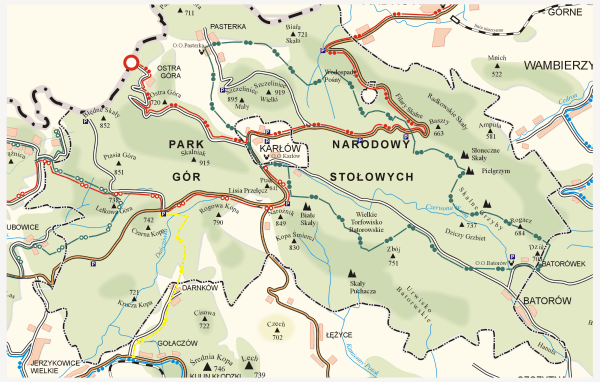
![]() The Stolowe Mts. route (blue) goes along the border of the park. This is an international route in Poland and the Czech Republic. The total length of the route on both sides of the border is 126 km. The routes goes through a border checkpoint in Tlumaczow - Gajow - Radków - Ratno Dolne - Wambierzyce - Studzienna - Chocieszow - Wolany - Polanica Zdrój - Szczytna - Duszniki Zdrój- Słoszow - Kulin - Gołaczow - Danczow - Kudowa Zdrój - a border checkpoint Czermna / Malá Čermná. The total length of the route in Poland is around 65 km.
The Stolowe Mts. route (blue) goes along the border of the park. This is an international route in Poland and the Czech Republic. The total length of the route on both sides of the border is 126 km. The routes goes through a border checkpoint in Tlumaczow - Gajow - Radków - Ratno Dolne - Wambierzyce - Studzienna - Chocieszow - Wolany - Polanica Zdrój - Szczytna - Duszniki Zdrój- Słoszow - Kulin - Gołaczow - Danczow - Kudowa Zdrój - a border checkpoint Czermna / Malá Čermná. The total length of the route in Poland is around 65 km.
![]() The Wall route (red) goes through the centre of the park. It goes on both sides of the border. In Poland it goes from Bożanov / Radków border checkpoint - Radkow - Karlow - Ostra Góra / Machovská Lhota border checkpoint. The Polish part of the route is 19 km.
The Wall route (red) goes through the centre of the park. It goes on both sides of the border. In Poland it goes from Bożanov / Radków border checkpoint - Radkow - Karlow - Ostra Góra / Machovská Lhota border checkpoint. The Polish part of the route is 19 km.
![]() Szczeliniec route (green) goes only in the area of the Park. It goes from Karlow - Pasterka - Droga nad Urwiskiem - Skalne Grzyby - Batorow - Karlow. The total lenghth is 24 km.
Szczeliniec route (green) goes only in the area of the Park. It goes from Karlow - Pasterka - Droga nad Urwiskiem - Skalne Grzyby - Batorow - Karlow. The total lenghth is 24 km.
![]() Masaryk route - an international bicycle route created in 2004. It is named after a statesman and the President of pre-war Czechoslovakia who in 1903 stayed in Hronov and made a lot of hikes and bicycle trips around the area visiting the villages and towns at the foot of the Stolowe Mountains. The route connects two border provinces: Nachod and Kudowa. The total length of the route in Poland is 18 km and it goes from Żd'árky / Pstrążna border checkpoint - Pstrazna (Skansen) - Rozdroże pod Lelkową - Jakubowice - Kudowa Zdrój - Czermna (Kaplica Czaszek) - Slone - Kudowa Słone / Náchod border checkpoint.
Masaryk route - an international bicycle route created in 2004. It is named after a statesman and the President of pre-war Czechoslovakia who in 1903 stayed in Hronov and made a lot of hikes and bicycle trips around the area visiting the villages and towns at the foot of the Stolowe Mountains. The route connects two border provinces: Nachod and Kudowa. The total length of the route in Poland is 18 km and it goes from Żd'árky / Pstrążna border checkpoint - Pstrazna (Skansen) - Rozdroże pod Lelkową - Jakubowice - Kudowa Zdrój - Czermna (Kaplica Czaszek) - Slone - Kudowa Słone / Náchod border checkpoint.
![]() Rytne-Karlow route - an international route connecting Rytne in the Czech Republic and Karlow. In Poland the route is 17,5 km long and goes from Kudowa Slone / Náchod border checkpoint - Slone - Czermna (Kaplica Czaszek) - Pstrazna - Rozdroże pod Lelkową - Polana YMCA - Szosa Stu Zakrętów (the Way of a Hundred Turns) - Karlow. Some part of this route agrees with the Masaryk route.
Rytne-Karlow route - an international route connecting Rytne in the Czech Republic and Karlow. In Poland the route is 17,5 km long and goes from Kudowa Slone / Náchod border checkpoint - Slone - Czermna (Kaplica Czaszek) - Pstrazna - Rozdroże pod Lelkową - Polana YMCA - Szosa Stu Zakrętów (the Way of a Hundred Turns) - Karlow. Some part of this route agrees with the Masaryk route.
![]() In the area of the Park there are also routes marked yellow which serve as links between the above-mentioned routes.
In the area of the Park there are also routes marked yellow which serve as links between the above-mentioned routes.
Tourists travelling along bicycle routes that agree with trekking routes should keep attention and remember to give absolute right of way to hikers.
Park Narodowy Gór Stołowych
ul. Słoneczna 31
57-350 Kudowa Zdrój
tel. +48 74/ 8661-436, +48 74/ 8662-097
fax. +48 74/ 8654-918
pngs@pngs.com.pl
Copyright by Park Narodowy Gór Stołowych